Monday, October 30, 2023

Johnny's Route to Heaven

This blog post was originally published on October 30, 2023.  You will see portions of this blog post in this pink color which indicate added commentary or edits to my original blog post.  The intent of the commentary and edits are to provide updates and additional information learned from my attempt of the route on November 22, 2023. 

We lost "an unforgettable man" and my oldest brother, John Franklin Cougnet, Jr. to ALS on July 8, 2023. 

John in Newport Beach in July of 2021

In memory of Johnny, I completed this route as a solo and unsupported run circumnavigating the Loch Raven Reservoir in Baltimore County, MD on November 22, 2023.  This route will forever be named, "Johnny's Route to Heaven" and it is published as an official route on Fastest Known Time for others to attempt the route and honor Johnny every time their name is added to the leaderboard.   I completed the route in 13 hrs, 46 minutes, and 17 seconds.


For several years, I personally mapped this course and concluded confirmation of every segment of this route.  To my amazement, I could not find record of anyone attempting to circumnavigate this very accessible reservoir just North of Baltimore City.  It is a very popular destination for fishing, hiking, mountain biking, and of course trail running.  It requires navigation, technical trail running, and offers terrific scenic views.  


The route around the reservoir is 56 miles long, one mile for every year Johnny lived.  It is intended to be done solo and unsupported as a symbolic gesture towards the suffering someone endures as ALS progresses.  I hope those that attempt this route in the future will recognize the meaning of this course and do it in memory of John and all the families worldwide that are impacted by this dreaded disease.


I completed this route the day before Thanksgiving (November, 22, 2023) which commemorates one of Johnny's favorite family pastimes in California, the Cougnet/Finn Turkey Bowl!  November is also National Family Caregivers Month and I wanted to honor his wife, Maureen for the amazing care and support she gave Johnny!   


A world without ALS can happen with people like us.  Please consider donating to The ALS Assocation.  Your donation will help advance important research and improve the lives of people with ALS, their families, and caregivers through vital programs, such as medical transportation, support groups, education, and advocacy.  Follow this link to my fundraising page:  

https://donate.als.org/fundraiser/4956576 


ROUTE DETAILS:


Here is a link to a CalTopo Map of the route where you can download the files in multiple formats: https://caltopo.com/m/4VE5S


The route is divided up into eight different segments to assist in navigation and description of the route.  All eight segments are to be done in order starting with segment 1 and back to the starting point through Segment 8.  This means you will navigate counterclockwise around the reservoir.  Being that the route essentially runs along the shoreline of a public water reservoir, you are able to continually refill your hydration stores at your leisure.  Despite the water being very clean, for safety, I recommend filtering or treating any water retrieved from any source.


As with all trail running, the middle of Fall through early Spring is the best time to attempt this route as the overgrowth of the forest will have diminished allowing the trails to be easier to navigate.  Regardless of the time of season, there are about 4.4 miles of trail within this route that have significant deadfall, overgrowth, and briars that may be difficult or impossible to run.  In the late Spring through Summer, some of the single track can get quite overgrown and really not great to run due to briars and overgrowth.  It is possible but be prepared to get pretty scraped up!


Segment 1 - NCR Trail to Warren Road - 4.88 miles, 616'+ -632'


The route starts at the gate located at the intersection of the Torrey C Brown Rail Trail (aka North Central Rail Trail) and Paper Mill Road.  There is plenty of parking at this location either in a large parking lot or along Paper Mill Road in both directions.  I started my attempt at 6:00 AM EST which was approximately one hour before sunrise.  My father was there to witness my start.  We planted a sign at the starting point to designate the start and finish of the route.
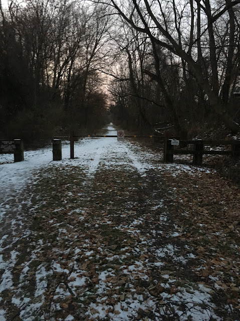

Start / Finish Point - Torrey S Brown Trail (NCR Trail) at Paper Mill Road


Start / Finish Marker of the Route at the NCR Gate

Proceed South to the next parking lot which is also the start of the Torrey C Brown Rail Trail.  You will continue through the parking lot and proceed to follow the abandoned remains of the North Central Rail Road.  There is a single track leading you alongside the abandoned rails towards a former railroad bridge to cross the river.  Only the main bridge span beams are intact which are about one foot wide, so you need to balance beam or shimmy your way across the bridge.  After crossing the bridge follow the single track to the river.  At this point, the trail turns into a mowed grass trail, and you will turn west to follow the river towards York Road.  


During my attempt, we had over an inch of rain the night before and the river had overflowed its banks making this area submerged in knee deep water.  There is a small drainage stream that had an ATV bridge across it which was washed away by the storm.  Fortunately, I was able to use a nearby fallen tree and a 2x6 that was floating nearby to build a bridge, so I didn't need to wade across chest deep water in the stream.  


Turn left onto York Road to proceed south towards Kelly Auto Body and turn left into their driveway and proceed to the abandoned railroad trail that is located behind their white buildings.  Proceed to follow the abandoned railroad route until you reach the location where the railroad would cross the river again, but the bridge is not there.  At this point, you will turn to the right and traverse through a small area of bamboo towards the backyard of several homes.  Follow their property line through the woods to intersect the Sherwood Trails.  This is undefined trail and will require some navigation through the trees to the trail head.  


Continue to follow the mix of single track and fire road as defined by the map.  It is fairly well defined and should offer views of the north end of the reservoir as served by the convergence of the Western Run and the Gunpowder Rivers.  


Segment 1 ends when the trail intersects with Warren Road at a small parking area.  There is a small stream that you will cross which has some deeper sections if you would like to filter water to refill.  It is fairly early in the route, but if desired, this parking area is a good location for support.  You will proceed left down Warren Road to begin Segment 2.

Parking Area at Warren Road - End of Segment 1

Segment 2 - Warren Road to Dulaney Valley Road - 5.22 miles, 515' -492'

Segment 2 follows much of the Merryman's Trail, of which portions were built by an Eagle Scout.  It is a very scenic trail including views of the Warren Road Bridge which is a very old steel, single lane bridge.  It is also includes some of the most technical of all the trails you will encounter during this route with rock scrambles, switchbacks, stream crossings, and single-track with undulating terrain.  If you are not warmed up by Segment 1, you will be after this segment!

You will enter the trail at the location pictured below:
Trail Entry at Warren Road - Beginning of Segment 2

Much of this segment is single track trail and has several stream crossings that you can refill your hydration stores.  It also runs very close to the shoreline in many places where you can refill straight from the reservoir.  

Close Proximity to Water for Refilling Hydration


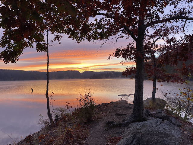
A moody picture of the reservoir on this segment from November, 2018

This area of trail is very popular with hikers and mountain bikers so be alert as you make your way through some of the single track.  I do not recommend wearing headphones in this part of the route as you will need to be listening for the mountain bikes depending on the day you are running. 


This segment ends at a small parking area at Dulaney Valley Road, just west of the large bridge crossing the reservoir.  If you are making a supported attempt, this parking area is a good location for support.

Finish of Segment 2: Parking area at Dulaney Valley Road

Be very cautious when crossing the road at this location, as traffic comes from the south around a blind corner.  You will run East towards the bridge and cross the guard rail that starts at the approach to the bridge to start segment three. 

Start of Segment 3: Cross Guardrail at this Point

Segment 3 - Dulaney Valley Road - 12.11 miles, +641' - 647'

This next segment is fairly flat compared to the first two segments, but it is the longest segment of the entire route.  It also has many areas that the trails are not as well defined, and you will come across a lot of difficult to run sections due to deadfall and briar patches.  You will proceed South along a meandering single-track path that makes it way to the Pine Ridge Golf Course.   There are a few fire road portions of the trail.   Aside from the fire roads, you can bank on the trail being fairly grown over with a ton of briar patches to fight through.  

North End of Segment 3

As you approach the golf course, you will follow the shoreline of the reservoir to make your way onto the 8th hole tee box where you will start your trek around the golf course featuring a couple out and back sections to adhere to the shoreline intent of the route.  Remain to the edge of the golfing holes and enjoy the views around the course.  Again, there are plenty of points where you can refill your hydration stores.  You also pass the 9th hole snack shack (you can only stop if you are doing a supported effort on this route).  The snack shack is only open during the Spring and Summer seasons.  As I entered the fire road area to the East of the 10th hole, I was starting to struggle from some stomach distress and fatigue that I didn't expect this early.  I was beginning to worry about my water supply and whether it may not be trustworthy.  I had to walk more portions of this area than anticipated.  The Fire Road trail shown is not well maintained either so I found myself meandering through the woods to stay on the route.  I was very happy to get back out onto the golf holes for some steady ground and clear paths ahead.

Run Around Pine Ridge Golf Course

This segment continues by exiting the golf course via the entrance road and turning left onto Dulaney Valley Road.  There is a wide grass area so that you do not have to run on the small shoulder of the road.  You will see an open fire road entrance on the left to continue on the route down a peninsula and return back to the same entrance to turn left again onto Dulaney Valley Road.  As I was leaving the golf course, my stomach distress was getting worse which I really didn't want at a point where I had nice open road to hit a steady pace.  When I finally reached the fire road, I had no choice but to stop and relieve myself.  Fortunately, that did the trick and I was immediately re-energized!  It wasn't the water! This is probably TMI for most readers, but this is a reality of long-distance efforts like this.  

Continue approximately a half mile past the Baltimore County Police Department Gun Range.  This area is closed to the public so you must continue down Dulaney Valley Road to continue on the route.  You will reach a guard rail section after the entrance to the gun range and see a grass meadow.  Hop the rail to drop down into the meadow and follow the meadow to enter the trails again for a short loop around the next peninsula before returning back to Dulaney Valley Road to run to the end of this segment at the intersection of Seminary / Hampton Road.  During my attempt, I missed the entry to the meadow and double backed several times as I kept thinking there must have been a more defined trail head.  Also, this area of trail is very tight, overgrown with a lot of fallen trees, and briars lining the trail making it nearly un-runnable.  It really took a lot out of me to make it to the fire trail back to Dulaney Valley Road. 

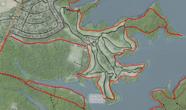
South End Map of Segment 3

Segment 4 - Seminary Road to Providence Road - 6.75 miles, +564', -476'

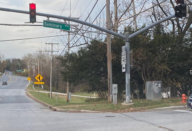
From Delaney Valley Road, you will turn left to continue East on Seminary Road.  You will see a clearly beaten down trail at the traffic light pole at this intersection which is easy to follow to re-enter the woods on your left.  This segment features mostly single track and continues to be very flat to start.  The route intersects with the Glen Ellen Trail which is an established gravel trail, however much of this trail runs along the shoreline and offers some expansive views of the reservoir.  In my opinion, this was the most enjoyable section of trails as it was well maintained, smooth, and scenic the entire way!

Start of Segment 4 at Dulaney Valley Road and Seminary Avenue

Overview Map of Segment 4

Where the single track meets up with the gravel Glen Ellen Trail, there is a nice stream crossing where I stopped to refill my 1.5L bladder with a MSR hand-pump filter.  It was a great place to recharge as well because the sun had finally broken through the clouds and there was no tree canopy, so it helped dry out my sweaty and wet clothing!


Before the end of this segment, there is a significant climb that signals the end of the flat portions of trail for a time... don't fret, they will be back later. 

Profile of Segment 4

As you make your way back to the bridge at Loch Raven Drive, you will come upon a nice scenic overlook.  You essentially run straight towards a beautiful overlook of the entire reservoir in almost 360 degrees.  You then climb down a rocky descent to Loch Raven Drive and turn back towards a fire road entrance on the right to climb your way back up to the trail.  

Scenic Overlook at Loch Raven Drive

This segment ends at the fire road gate at the intersection of Providence Road and Loch Raven Drive.  There is a small parking area at this location and is a very popular area for running groups to meet up on weekends.  On Saturday and Sunday, Loch Raven Drive is closed to vehicles from 9 AM to 12 Noon from this point and to the North and West to Morgan Mill Road.  Unfortunately, you don't get that short cut, you have to go the long way around the dam to that point in the next segment!

Segment 5 - Providence Road to Morgan Mill Road - 8.49 miles, +882' -964'

You are now on your way to the southern tip of the reservoir which requires navigating the shoreline trail to the Loch Raven Dam.  Although this segment is a net descent, the large descent is in the middle to get you down and around the dam.  Prior to getting there, you drop down from Providence Road to the reservoir via an overgrown fire trail.  From there, you trace the shoreline all the way around, so you get a great view of the dam from the reservoir side.  This section of trail really challenged me as it was on a side hill nearly the entire time making your stride very awkward.  My legs were already feeling rough, and this section ground me down to a walk in many areas because of the uneven ground.

Overview Map of Segment 5

You eventually exit the shoreline trail via a steep climb to the roadway just above the top of the dam.  From here, you will enjoy (if your legs can handle it) a long steady descent all the way down to Cromwell Bridge Road and turn left.  Unfortunately, during my attempt, I struggled to muster the desire to run down the hill to Cromwell Bridge Road.  I was frustrated as this was all free speed and could get me back on track.  I elected to fast walk it the best I could, gather myself and prepare to run the entire segment of Cromwell Bridge Road back to the trails.  This was the start of a dark patch for me. 

Cromwell Bridge Road is a two-lane road with little shoulder so be sure to run opposing traffic and be prepared to move as close to the guardrail as possible.  This portion is only about 0.5 miles and is all downhill so you can pick up the pace to get back to the safety of the sidewalk as you turn left to continue onto Glen Arm Road.  You will run about a quarter mile to turn left onto Hoover Lane which essentially seems like a long driveway.  There are several homes along this road, and you will veer off to the left into a corn field access road to lead you back to the reservoir trails.  Fortunately, my plan worked and I was able to hold a solid pace as I turned onto Cromwell Bridge Road and made it all the way to Hoover Lane.  I had not broken through my dark patch yet, but this was a small win!

Profile of Segment 5

At this point, you will follow the single-track trails back up past the dam and connect with Ridge Trail.  This is another scenic area of the trail overlooking the reservoir and following the property line of the reservoir with private residences.  Unfortunately, I mistakenly took the trail to the left that climbed straight up the hill adjacent to the dam.  There is a bypass trail to the right that is far less steep and how I originally mapped the course.  They both essentially climb the same elevation, but the one to the right takes a far less severe average gradient.  The view however at the top of the wrong trail was pretty nice and a unique one from overtop the dam.  At the top of this hill, I had to pause and regroup.  This was the peak of my darkness for the day.

View above Dam on Ridge Trail

You will follow the Ridge Trail to the power line easement and turn left down the trails that will wind in and out of the easement for a short period of time.  You will come upon the fire trails in this area and follow them until you come upon Morgan Mill Trail making your way back down to Loch Raven Drive.  My dark patch continued until I reached the Morgan Mill Trail.  Prior to this point, I focused on my hydration and really sucked on my liquid nutrition to see if I could get some fast calories to break through.  I also grabbed some of the trail mix that I stashed into my pack at the last minute.  I have never used this before in any event, so I was taking a big risk here.  Based on the result, this could have saved my day because shortly afterwards, I broke through and found my run legs again.  You will run along Loch Raven Drive for about 0.5 miles with terrific views of Goose Island and the reservoir as a whole.  Segment 5 ends at the gate at Morgan Mill Road.

Segment 6 - Morgan Mill Road to Dulaney Valley Road - 8.8 miles, +397' -389'

Welcome back to the flats!  Although this section is flat, it does have some challenging areas to traverse as you will have to literally run on the shoreline in many places.  With the reservoir level being down for so many years, the shoreline trails have become overgrown in this area since folks can just walk on the formerly submerged areas.  This leaves the route rocky with a lot of deadfalls laying around.  Watch your step and proceed with caution.  This first part of the segment was indeed slow as I simply had to walk most of it due to the uneven ground and wobbliness of my legs.  I did not want to afford a twisted ankle with so many miles left to go.  You will make your way back to Loch Raven Drive to run towards Dulaney Valley Road at Peerce's.  You could schedule a congratulatory dinner there once you are finished, it is terrific!  

Overview Map of Segment 6

Run along Dulaney Valley Road in the grass and look for an entrance to a grass fire road before you reach the entrance to the Loch Raven Trap & Skeet Center.  This fire road is mowed grass the entire way around the Skeet Center and returns you around to the entrance road to the Center where you will find your way back onto Dulaney Valley Road.  This is a fairly nice fire trail to run, and you can clip off the miles steadily.    

Continue on Dulaney Valley Road to the Hunter's Parking Lot on the left and follow that fire road to do a loop around that peninsula.  This loop is mostly packed gravel and paved with solid footing and you can continue at a nice pace through this section as well.  You will continue following Dulaney Valley Road to the Loch Raven Fishing Center entrance road and head to the shoreline.  For these last two portions of the segment, I maintained an average pace just over 12 minutes per mile and was very happy to be moving so well at this stage of the run.  Unfortunately, after reaching the shoreline past the Fishing Center, that all came to an abrupt end due to the trail conditions.

Entrance to Hunter's Parking Lot off Dulaney Valley Road

You will follow the shoreline for the majority of this peninsula with a small section that will require some bushwacking to make your way to the other side of the peninsula. Continue following the shoreline back towards Dulaney Valley Road.  Just before reaching the road, you will get into a very marshy area with a stream pouring into the reservoir.  This is the most likely area you will encounter mud and need to navigate about 200' through the brush to get back to Dulaney Valley Road.  There are hunter and game trails making their way through, so stay persistent and you may have to work through some briars to get back to the road.  With the overnight rainfall before my experience, this area was super squishy and a challenge but was still navigable.  It was just another location where my feet got wet! 

View of the reservoir from the fishing center shoreline.

Once again, continue West on Dulaney Valley Road to the entrance to the next loop of trails around the last peninsula of this segment.  If you reach the guardrail to the bridge approach, you have gone too far and need to double back to find this trail's entrance.  These fishermen trails are very narrow single-track.  Stay glued to your GPS tracking to remain on the trail or you might find yourself in meadows of open area that are surrounded by briar patches and need to double back.  At this point in my attempt to do this route, shoreline running was impossible due to fallen trees and large rocks.  I ended up walking the remaining portions of this segment and was resigned to the fact that I was finishing this thing in the dark.  As you make your way to the west side of this peninsula, the trail opens up all the way to the bridge abutment.  Be sure to refill your hydration stores before starting Segment 7.  The first part of the next segment is difficult to get to the water initially.  Cross over the guardrail onto Dulaney Valley Road and this will mark the end of Segment 6.  

Dulaney Valle Road Bridge looking towards the Northwest from near the end of Segment 6

Segment 7 - Dulaney Valley Road to Merrymans Mill Road - 4.12 miles, +463' -477'

You need to cross the intersection of Dulaney Valley Road and Jarrettsville Pike.  This is a very busy road but has a traffic light to control the flow of traffic so proceed with caution and you will be fine.  There is plenty of parking up and down Dulaney Valley Road for support vehicle staging, if desired.  The entrance to this segment can get overgrown but look closely as the note on the map suggests, the entrance is about 10m from the end of the guard rail on the Northwest side of Jarrettsville Pike.  This trail entrance was indeed very overgrown during my attempt and I ended up charging through to the backyard of the home you see in the image below.  I found my way down the hill and intersected the route.

Road Crossing Map at Dulaney Valley Road and Jarrettsville Pike - Start of Segment 7

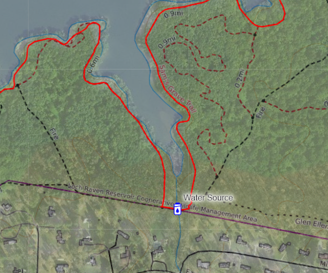
You will follow closely to the shoreline here, but this is a trail that traverses the contours along a steep hillside.  With your legs fatiguing at this point, the uneven ground will bother you!  Stay focused and you will be fine!  Fortunately, I still had some run legs and did my best to move swiftly.  The sunlight was fading quickly but visibility with my headlamp was still pretty good.  You will continue around this shoreline trail and you will eventually intersect with the Blue Trail very close to Jarrettsville Pike.  The Blue Trail is a wide gravel trail which you will follow for about 0.9 of a mile and then turn left onto a single-track trail that brings you back in touch with the shoreline of the reservoir where you can refill your water.  I continued to run the downhills but also noticed that I actually felt better continuing to run the "uphills" as long as I could.  Downhill running is far worse on the legs and my legs feeling it at this point!

A Nice Location to Refill Water Stores

You will continue on single-track until you intersect again with the Blue Trail.  Before you get to Merrymans Mill Road though, you will turn left onto single-track one more time for this segment to finally reach Merrymans Mill Road a little farther down than where the Blue Trail ends.  This section of trail is not really conducive to running due to overgrowth and fallen trees.  In the dark for me, this was very slow going having to lift my legs over trees and brush!  My pace was drastically falling from 14 minutes / mile to over 20 minutes / mile.  With no cell phone service, my tracker was failing to communicate with my family so I was doing my best to send check-ins from my Garmin InReach Messenger to make sure they knew I was ok.  It was clear, I was going to be several hours past my original goal.

Northern Part of Segment 7

Segment 8 - Merrymans Mill Road to Finish - 5.87 miles, +993' -994'

Here it is, the last segment!  Sorry to say that it will be highly technical, getting dark, and your legs will be screaming at you with the amount of elevation left to climb on this one!  You will proceed West on Merrymans Mill Road towards a trail just after the guardrail.  This trail heads back down towards the shoreline.  Much like the last portion of segment 7 towards Merrymans Mill Road, the first part of this trail is overgrown, lots of deadfalls, and was very slow going for me as I simply could not get any momentum to run.  If you have anything left in your legs, you might be at a fast-walking pace but don't expect much running until you get to the Orange Trail.  

Southern Part of Segment 8

Best to refill here as there are not a lot of locations left on the route.

You will link up with the Orange Trail and continue along the shoreline.  If there is still daylight, before the trail turns west along the shoreline, you will get a terrific view straight down the reservoir.  From this view point, you will climb perpendicular to the grades to continue on the Orange Trail.  This climb is very steep and very rocky further taxing your legs in an already fatigued state.  Once on the Orange Trail, you simply follow it until it intersects with another fire road and turn left towards Warren Road.  This is a fairly steep descent to the road so your quads will definitely be screaming at you this late in the run.  Fortunately, it is short, and you will spill out onto Warren Road and get up close and personal with the Steel Bridge you saw many hours ago in Segment 2!  In the dark, this descent was far more treacherous as the last 30 yards is very steep, rocky, and covered with tree routes. 

Warren Road Bridge as you proceed North towards Paper Mill Road

Cross Warren Road and head into a meadow like area to begin working your way around the Northern end of the reservoir.  These are the headwaters of the reservoir which is formed by the convergence of the Western Run and Gunpowder Rivers.  You are in the home stretch but not out of the woods yet of the technical terrain!  You will continue to follow a fire road that essentially runs along the top of the ridge line looking down on the river.  Before you get there, you essentially need to climb straight up the grades to intersect the trail.  This is an undefined trail, and you are simply navigating your way perpendicular to the contours.  The trail is covered with think ivy which covers many fallen trees and will definitely require a ton of concentration as you use all your energy to climb.  The former fire road connection from this area to the portion you are trying to get to, has become extremely overgrown and is completely unpassable.

Fortunately, when you reach the fire road, this is a fairly straight shot and does not require a lot of mental power to navigate back to Paper Mill Road.  At this point, I was basically walking.  Every time I felt the urge to run, there would be a fallen tree across the trail and completely disrupt any momentum I was trying to gain.  I was fed up and tired of climbing over deadfall at this point!  You will turn off to the left to descend down to Paper Mill Road.  Similar to the descent at Warren Road, it is steep and short, and will no doubt remind you that your legs are trashed at this point!  But this is it, the real home stretch, but there are a few surprises left!  Unfortunately, in my fatigued state, I found myself off the clearly defined trail and boxed in by brush just before reaching the last 20' before the drop to the bridge.  I essentially had no choice but to barge myself through.  I could see a car parked in the small lot at the bridge and heard voices of some young folks under the bridge hanging out... I must have sounded like Sasquatch crashing through the forest above them!

"The Home Stretch" - Paper Mill Flats to Torrey S Brown Rail Trail and the Finish

When you empty out onto Paper Mill Road, you will come upon two bridges.  Cross the river on the newer of the two bridges... you'll know why when you see them!  When you reach the end of the bridge, cross over the guardrail and proceed to climb your way down the bridge abutment to the Paper Mill Flats below.  The rocks are very large and secure, and you can slide down them on your bottom if you are so sore that your legs won't support your weight at this point.  From here, you need to navigate down river across the marshland.  The marsh is very wide (several hundred feet) but you must find your way through dry ground.  It is possible and if it is dark at this point, turn your headlamp on full blast to get the best view of your footing. 

You are going to proceed to just about the point where the Gunpowder and Western Run meet and turn hard right to climb your way back out of the river gorge.  You will proceed up until you reach the fire road and turn left and follow along the ridge line towards an outcropping of boulders on your left.  Follow the trail down the hill and to the spine of the ridge.  Watch your footing closely with your head lamp on full blast to navigate the pinnacle rock and boulders that liter this spine of the ridge at this location.  When you reach the end of the spine, there is a very steep drop to your left that you can carefully descend down to the trail that takes you the rest of the way down the ridge.  There is no shame in sliding down this on your butt!  This is the last of the technical sections of trail!  

You are going to proceed down into a flat area and follow the shoreline trail.  Follow closely to your GPS because if you make a wrong turn here in the dark, you can find yourself in a dizzying maze of mountain bike trails that will trap you going in circles for hours.  You will then pop yourself out onto the Torrey S Brown Rail Trail and turn right and make your way back to the starting point at the gate at Paper Mill Road.  Congratulations, you completed Johnny's Route to Heaven!  

Fortunately, this is the area of trail that I run most frequently and could have finished without a headlamp.  My headlamp was fading at this point as I never dreamed I would have needed it for four hours on this journey.  However, being only my second ever ultra run, I learned that you really can't predict how these things are going to go.  Fortunately, I was able to essentially run the last mile and half and meet my family.  Amazingly, they were tailgating in the parking lot of the NCR trail since 5:15 PM!  I arrived at the gate at 7:49 PM!  They were all troopers to hang out in the dropping temperatures to provide me a wonderful welcome home!!

The following video compiles the entire journey including our fundraising efforts and how the day went setting the first fastest known time for this route!  


Here is a 3-minute fly-thru Google Earth Video of the entire route showing the 8 segments detailed in this blog post:

Below is a picture of my pack, equipment, and the 4,000+ calories that I packed for my solo and unsupported effort.  


From left to right:
  1. First aid kit - You never know and my wife will be happy to know I carry one.
  2. Garmin InReach Messenger Satellite GPS transmitter - I will be sending out a web address to all of you where you can track my progress next Wednesday.
  3. MSR Trail Shot Water Filter
  4. Salomon 12L Running Vest
  5. (2) Salomon 500 ml flasks with integrated filter straws
  6. SportsTrail 1.5L Bladder - This will be filled with my liquid nutrition mix
  7. (6) Science in Sport - Go Energy + Electrolyte Gels
  8. (4) Vafels Stroopwaffels
  9. Salt Stick Electrolyte Fastchews - I will carry a small bag for spare electrolytes in case I need them.
  10. (4) UCAN Edge Superstartch Energy Sachets
  11. Flow 60/90 Hydration & Energy Mix which will be enhanced by Beta Alanine, Magnesium, and Salt Stick Electrolyte Capsules
  12. (3) Maurten Gel 100 / CAF 100 - The only caffeine that I will be carrying for the day however I will no doubt have some coffee in the morning before I start.  ðŸ˜ƒ
  13. NAAK Ultra Energy Mix - This will be added to my Flow 60/90 Hydration and provides a protein source for the day.  This is typically a no-no for triathlon but for a long-slow day, having some protein will help sustain my muscles and help my stomach feel full (at least I hope so).
  14. (2) Vafels Wafels - Nice dense solid food in case my stomach starts growling.
My nutrition worked out perfectly for this effort.  I ended up on-trail over 2-1/2 hours longer than I planned.  Fortunately, on a whim and not listed above, I shoved a sandwich bag of trail mix into my pack at the last minute.  I absolutely needed this extra stash of food and the added fat of the peanuts and almonds in the mix were probably the saving grace for me finishing this attempt!  The Salomon 500ml filter flasks were absolutely perfect for fast refills on water!  

Here is a picture of my kit that I will be choosing from during the attempt:


  1. MerinoTech 100% Merino Wool Base Layer Shirt - If raining, I will start with the short sleeve shirt and bring the long sleeve as backup.  Otherwise, I will reverse the choice if it is not raining because I will opt out of the jackets and pants.
  2. Gorewear - R7 2in1 Shorts - Hoping to wear these from the start and not be in pants.
  3. Gorewear - R5 Gore-Tex Infinium Pants - I really hope not to wear these but it will be a decision at start time.
  4. Gorewear - Drive Jacket - This is a lightweight shell which is also water resistant.
  5. Saucony Peregrine 13 Trail Running Shoes - I have more pairs of trail running shoes than my wife prefers but these are the lightest and most comfortable.  They are not waterproof like other pairs I have, but I am banking on it only being showers for the morning.
  6. Currex Runpro High Arch Insoles - Secret weapon to ward off fasciitis!  
  7. Swiftwick - Flite XT Trail Five Socks - These are a mix of 38% Nylon, 24% Merino Wool, 22% Olefin, 13% Polyester, and 3% Spandex... super durable and awesome at keeping your feet dry!
  8. Bauerfiend Sports Ankle Support Dynamic - Just a small bit of ankle support for trail running and not too bulky.  Wear under your socks!!
  9. Nathan Running Belt with See-Thru Pouch - For stashing my phone to remain connected.  I will be wearing Shokz Open Run bone conducting headphones in case I need to call anyone (or anyone needs to call me).  I'll also be carrying my travel plan in the see-thru pouch to check on my progress as I go.   
  10. SmartWool Merino 250 Glove - My hands sweat a ton so wool gloves are the best at keeping you warm despite being soaking wet.  
  11. Fenix HM65R-DT Trail Running Headlamp - Super light and super powerful when needed!
  12. Boco Gear - Technical Trucker Hat - California Golden Bear in honor of my California family!  Plus it is hunting season out in the woods, need to be visible!  
I was very fortunate the rain had moved out around 2:00 AM before starting at 6:00 AM.  The temperatures also didn't drop very much because of the cloud cover so temperatures stayed right around 50 degrees F to start.  Therefore, I only needed to wear my MerinoTech long-sleeve shirt for the entire run.  It was definitely torn in several places due to the briars but it was a perfect!  Despite getting wet feet in the first mile of the day, the combination of my Saucony shoes and the Swiftwick socks also were perfect.  I did not get any blisters, hot spots, or other foot troubles other than some banged toes with nails that will be black for a few months.  The Bauerfiend Sports Ankle Support sleeves were also the perfect balance of support for this run.  I was mildly worried that I might create a rubbing location of my arch or around the top of my foot but surprisingly, no blisters, chaffing, or pinch points developed.