Like so many of us committed to racing this year, our dreams of personal records and new events were squashed by COVID-19. My season had one focus and that was representing Team USA at the ITU AG Standard Distance World Championships in Edmonton, Alberta, Canada. Unfortunately, like all my other races, it was cancelled. As of mid-June, there was still no word from Team USA as to what they are going to do with us who qualified. Will we be the 2021 team or will they make us re-qualify? So with all my motivation thrown out the window, I needed another challenge. For the past sixteen weeks of COVID quarantine, I have struggled to find something that would inspire me to train hard. I have maintained my training discipline, but it has just not been the same.
While hiking on Memorial Day (May 25th) with my family on a trail near my house, the inspiration hit me. I decided to attempt the Appalachian Trail Four State Challenge on June 20. My goal was to do it in under ten hours including breaks. This is an average of twelve minutes per mile for the anticipated 42.5 miles.
Prior to setting out to do this, I have never run more than seventeen miles in a single effort. However, I have built up a ton of mileage over the past five years of racing so this was not outside of the range of possibility. Fortunately, for the several weeks prior to making this decision, I had been logging between ten to fourteen miles on my Sunday long runs so I had some distance under my belt and just needed to continue to build. With only four weeks to prepare and log some serious mileage, I knew this would be exactly the challenge I was looking to do!
My father, John, agreed to support me along the way. He and my mom, Ruth, have been amazing supporters for all my races in the past and they both stepped up big time again! He was as excited as I was because he is very familiar with this part of the AT. Many moons ago, he did the solo challenge unsupported over the course of a weekend backpacking his way. He had never backpacked before at this point in his budding passion for hiking and it was indeed a challenge for him. In a way, I wanted to relive that story with him. Below is the breakdown in how we approached the effort and planned our rest/refuel/reload stops.


This was my packing list of nutrition and gear:

During the work week, my training remained much the same although I added volume to my Tuesday / Thursday rides and reduced their intensity. These were steady zone two for 1:30. My Wednesday runs ranged between 1:15 and 2:00 and were all trail specific runs. I would run these efforts faster than my target pace for the challenge. On the weekends, I ramped up my bike volume on Saturday and attempted to find hilly terrain. I kept the rides fairly easy, rarely venturing more than tempo and mostly aerobic. Again, I just wanted to build endurance.
Sundays were all focused on trail runs at my target pace, testing my equipment, and practicing my nutrition plan. I did all my Sunday runs on the Merryman Trail at the Loch Raven Reservoir. Each week was either two or three loops of the trail. These efforts were 18.3, 19.5, and 17.5 miles, respectively. I simply did not have enough time to ramp up higher than this without risking injury. I am not necessarily going for a record here, so all of these efforts were at a zone two heart rate. During my final long run the Sunday before, my lower left leg below my calf and above my Achilles tendon started aching in a weird way. Taper week was devoted to rest, repair, and praying that this tenderness would not impact me on the big day. I alternated ice, heat, and electric stimulation to the area all week and I am happy to say it did not pose a problem!

The day before I was energized and feeling the pre-race nerves that I have so longed for this year. Albeit to say, they were a bit higher for this effort than my last few races! I was hardly able to sleep like usual before a race and I was wide awake long before my alarm at 4 AM. Dad arrived right on time as always and was ready to go. We loaded my gear box and cooler in his truck and headed off to Pen Mar. I was pretty much packed for a weekend of camping for a single day effort! The weather forecast in the morning was predicting scattered storms all day long. I certainly prayed that it would hold off until late afternoon giving me a chance to finish before the heavy stuff started.
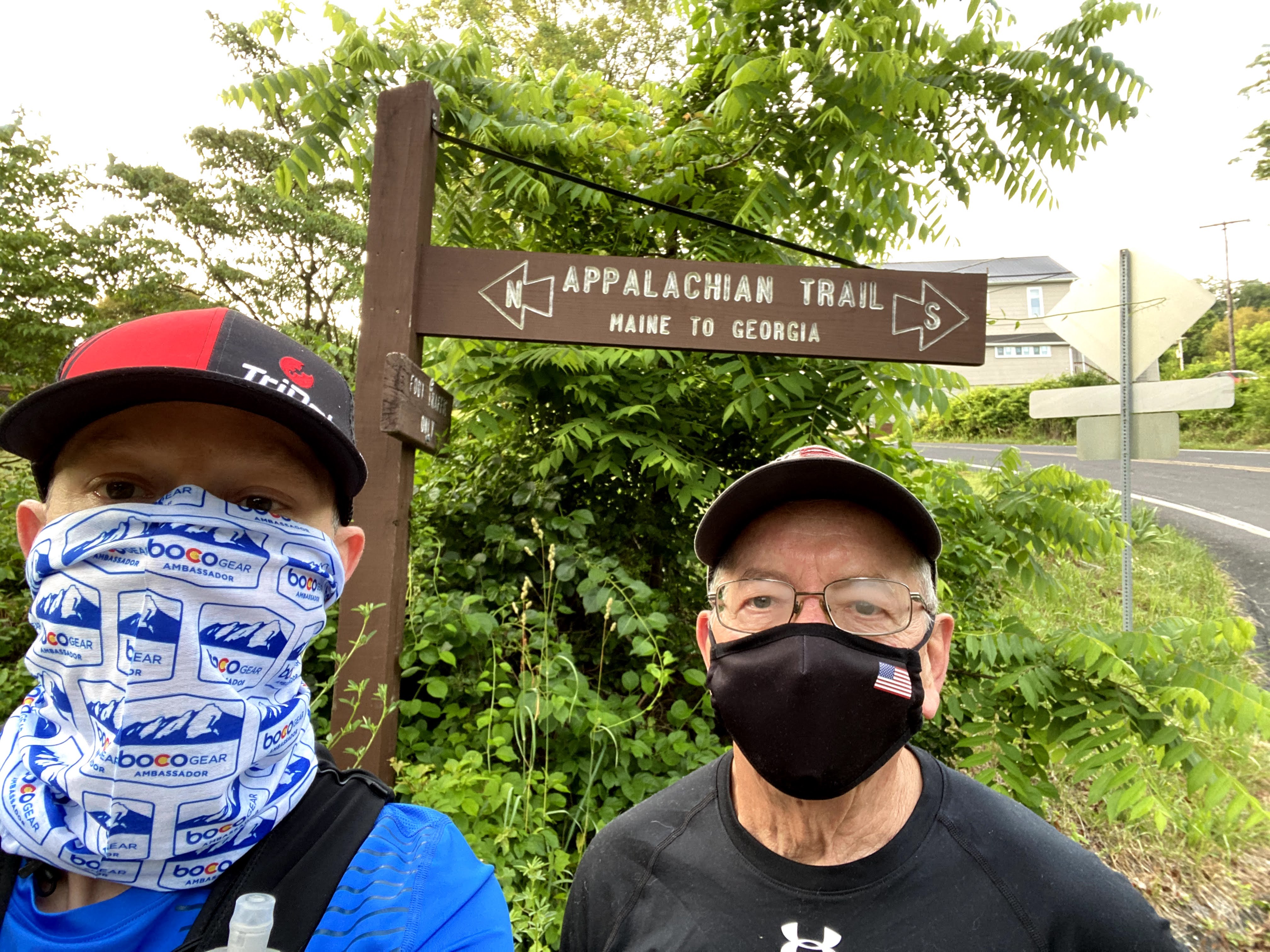
I chose to start on the Northern side because it is a net elevation loss. Although, there was still over 7,000 feet of elevation to climb. The drive to Pen Mar was routine and took about an hour and a half. We arrived around 6:30 AM. As we pulled in, I began drinking my pre-workout shake of UCAN with protein, caffeine, and oat milk. I did a bit of a warm up to loosen up and pulled my gear together. We did the obligatory "selfie" at my starting line which was about 0.1 mile from the Mason-Dixon Line to be sure Pennsylavnia was logged properly on my GPS. This also allowed an opportunity to be sure my LiveTrack was working and that Dad could see me on his phone as I circled back to Pen Mar Park. I officially started at 6:52 AM, about 8 minutes ahead of plan.

My research on the first segment really had me concerned that this would be the hardest part of the run as I would be climbing to the highest part of the trail in Maryland called Quirank Mountain. Despite being about 608' of climbing over 1.2 miles (9.0% grade), the climb was far easier than I was anticipating although it was populated with large boulders and a lot of slow scrambling. The vast majority of this segment was rocky but still comfortable in finding decent footing and a good rhythm to my stride. I was feeling good and all indications was that the taper treated me well and I was ready to go!


The last part of this segment had a variety of terrain including farm land, stream crossings, and interesting rock outcroppings. I am happy I brought my phone/camera along as it really helped to pace myself and not go out too hard. You'll notice as this report goes on though, my pictures become less and less, I wonder why?


I finished the first segment of 9.66 miles in a time of 1:59:54. My plan was to finish this segment and start the next in a total time of 2:31, so I was pretty far ahead of schedule. I was not concerned as I knew I really took my time to pace well and just benefited from easier terrain than I originally anticipated. My rest stops were all pretty much the same. Dad had my chair and UCAN shake ready to go when I arrived. On this first stop, I had to change my shoes and socks as I was soaked through. I had hoped not to have to change shoes this early, but I did the right thing to keep my feet dry. I had four 500ml water bladders, so two were in my vest and two were filled, chilling in the cooler for the next segment. This worked well. I took one GU Roctane tablet at each rest stop. In hindsight, two might have been better than one. Otherwise, the Honey Stinger Gluten Free Waffles were a great solid food option on the trail. Occasionally, I would mix in a Science in Sport gel for added boosts of electrolytes or caffeine.
The next segment was one that I was looking forward to as I was going to take a small detour to witness the view off Annapolis Rock. My wife Tammy and I visited here when we camped at nearby Greenbrier State Park. Overall, this section was fairly tame with mostly rocky terrain with decent foot holds. I felt fairly good during this segment as it was essentially in my training wheelhouse. However, as I knew from training, running downhill is far more strenuous and this segment concluded with some large earth steps for nearly three quarters of a mile and my legs were talking a bit heading down.


I texted the above photos to Tammy and she replied, "Lookin' good! Hope the heat is tolerable!" Indeed it was! Additionally, she sent one more text telling me I forgot to bring my Dad's Fathers Day gift. I remembered his card though. Can you imagine my eye roll!?
Segment 2 went down in 1:34:77 for 8.77 miles. I completed the segment at 10:35AM which was still ahead of my plan and I was feeling fairly strong. This part of the trail dumps out at Route 40 and I-70 and was really the most exposed area of the trail to the sun and it was hot. At just over 18-1/2 miles, I was approaching the longest distance I have ever run in a single effort. I knew I was about to journey into the unknown of what my body was able to do.
My next segment highlighted Washington Monument in the last few miles. It was also the shortest segment of the day. It featured a series of punchy hills venturing up and down in quick succession. I was starting to get hot during this segment and felt like hydration might be lacking. I squeezed in an electrolyte and caffeinated gel and was feeling better rather quickly. I only stopped at the monument for quick photos and moved quickly out of there.


I finished segment three in 53:56 and arrived at Turners Gap at 11:46 AM. My total elapsed time at this point was 4:53:04. I was just over half way home and I texted my coach Sierra at that point, "More than half way. Feeling ok, getting tough now." She encouraged me with, "Nice. It's mental now. You got it!! Praying." Little did I know...
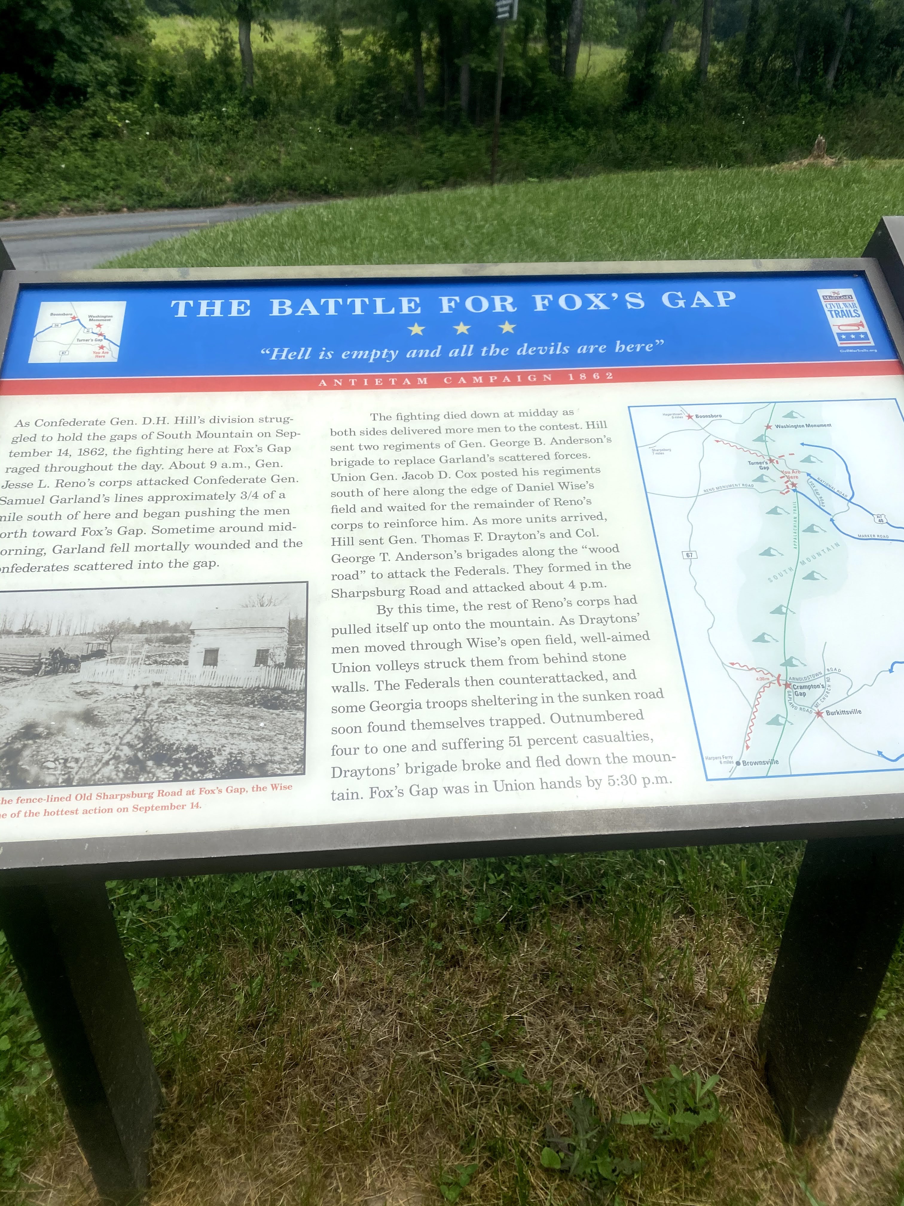
I began the next segment from Turners Gap to Crampton Gap with optimism that I would start trending downhill from here (literally, not figuratively). I failed miserably to research what I was in for over the next 7.2 miles. This segment started off with some reasonable ups and downs and I was able to keep a decent pace
initially. I was excited knowing that I was going to log my first marathon ever and clocked it at 5:44:07. Obviously not a Boston qualifying time in the slightest, but I doubt many people would use a course like this to
qualify.


"Lambs Knoll" is a climb that I renamed, "Soul Crusher". This was a
755' climb over 1.52 miles which is an average 9.0% grade. It had many
grades steeper than anything I had seen all day and I felt it. On top
of that, any flat section was littered with large rocks and there was no
where to step with flat footing. Every step felt like a lottery that I
would lose with a twisted ankle! Amazingly, I only stubbed my left and
right big toes twice each and went down to my hands twice and left this section with my confidence in tact (tongue firmly in cheek). I was convinced that I had done that section so slowly that all the
the time I was ahead on my plan was lost. Not to mention, I was starting to doubt this was a good idea.

As I completed that segment, I forced myself to stop and take a picture of an old ruined building and regroup. As I trotted down the hill to the car my dad asked me how that section was and I said, "It sucked!" I was tired and beat down. This rest stop was the most critical to get my head on straight. To my surprise though, I had
lost little time on my overall plan and that helped to raise my spirits. Dad also helped me focus on the next segment. I finished in 1:35:27 for 7.12 miles and I was still over twenty minutes ahead of my plan.

Crampton Gap started off with a small climb up a road past a monument to the "Press" and to return to the trail. I was immediately greeted with a sign that read, "6 miles to Weverton Cliffs" defining what I had next to do. I knew the descent after the cliffs was going to be steep and slow so I was hoping to plod along smoothly along the flatter sections towards the cliffs. Fortunately, the terrain was more reasonable and my tired legs were holding up. Unfortunately though, the rains came! A steady downpour drenched the trail and I was running through inches deep of water for several miles. Mentally I was beginning to struggle to remain focused and worked hard to remain in the moment. Knowing I only had two 10k's left helped. I run that distance and more every single training run, so I know I can manage it. I started having to walk a fair amount to navigate the deep puddles and rocks. At this point, every step was forward so I remained calm.
I reached the top of the switchbacks of Weverton Cliffs and I was immediately greeted with super weak legs trying to hold my position climbing down. Fortunately the rain had stopped as this portion would have been treacherous with water pouring down it. It is hard to describe these switchbacks. They were not flat except for the mid-sections. At the sharp turns, it would drop five or six feet and you had to ease your way down. My quads wanted nothing to do with this! To add insult to injury, mid-way down I wanted to take a picture of the upper levels to show how far I had traversed down. I pulled my phone out, started repositioning it for the shot and it flew out of my hands and off the side of the switchback! I stood there and watched it tumble thirty feet down the embankment which was nearly vertical. I deliberated with myself for a moment before I decided to try and slide down and get it. The adrenaline rush that ensued was nice for a brief moment. Amazingly, the Spigen Armour Case it was in held up and there was zero damage to the phone. The waterproof bag it was in was a different story as the bottom had torn. I did not notice this until later though and fortunately my phone did not suffer any water damage from here on out. I climbed back up and proceeded to inch my way down. As I approached the bottom, I came upon two hikers and one was sitting on a rock and clearly in pain. I paused and asked if she was alright and if she needed first aid. Fortunately, her hiking partner had a kit and they said they were good to go. The switchbacks at Weverton Cliffs descend 807' in 1.38 miles which is a 10.8% average grade! This was as hard as the majority of the climbs of the day.
I recorded the 6.7 miles from Crampton Gap to Weverton Road in 1:30:48 and I only had 5.5 miles left to the finish. My total elapsed time at this point was 8:45:00, I had more than an hour to reach the finish and my sub-ten hour goal. As I was getting ready to head out of my rest stop, Sierra texted me "go jay go", then another "go". I sensed urgency in her text as I began to realize that she was right! I have one more big climb to do. I headed out and fortunately was on flat road for the first 3.3 miles of this segment.
Due to a train incident last year, the pedestrian bridge over the Potomac River on the AT was damaged and closed. This required me to plot a detour and run along Route 340 across the Potomac. The night before this challenge I realized I never looked at aerial photography to see if the bridge was even cross-able on foot. To my surprise, it looked like the walkways were blocked off with steel cribbing holding the jersey walls in place. So unfortunately, I was planning on not being able to cross on foot and arranged with Dad to pick me up on the MD side and drive me over and drop me off immediately afterwards in a scenic pull-off lot. As we approached the bridge in the truck, to my surprise you could walk across as evidenced by the hiker I witnessed crossing. Dang nabit! We pondered for about half a second of turning around and having me run, but I just said, "no way." In the car though, I was able to set personal records for the 400m, 800m, 1k, and 1 mile that would probably break world records! Ha ha! This unfortunately disqualified me for the Fastest Known Time segment that I had registered for online. The record was never in danger though.
Anyhow, after being dropped off I proceeded to run along the shoulder of Route 340. This was the DUMBEST part of the entire day! This road is extremely busy, the shoulder is almost nothing, and it was sloped with gravel. I was already in pain and it was extremely exposed and sunny. I was baking! I finally reached the West Virginia line and snapped a picture from across the street. Amazingly, I kept plodding along at a reasonable 11:00 per mile pace and reached the bridge into Harpers Ferry where the AT connects. I hopped the jersey wall and went down the steps to cross back under Route 340 and begin my last ascent.

The climb up from Harpers Ferry to the Virginia border includes the overlook called Loudon Heights. This climb was 834' in just over 1.34 miles which is an average grade of 11.4%. Again, ignorance was not bliss in this case as I did not look closely at this prior to doing this challenge. Step after step was excruciating at this point and I simply just kept hoping the VA border sign was just ahead. Not to mention I was trying to think about what it would be like walking the 2.5 miles back to Harpers Ferry where Dad was parked. Halfway up, I crossed Chestnut Hill Road and I knew I was going to ask that someone pick me up there because there was no way physically that my legs would make it down that first part. It did not get easier from there and I simply just kept trying to keep moving. Things started leveling out and I was looking at my watch as time was ticking away and my sub-10 hour goal was looking like it was in danger. I clicked my watch over to my route map for the first time all day to see how many miles left and I nearly gave up when I saw I still had over a mile to go. I found some energy to try running again and surprisingly when the ground was flat it felt better than walking but my heart rate was maxing out and I just could not sustain it. I was teased by a sign that was pointed the opposite direction on the trail as it was for announcing the border of the Harpers Ferry Historic Park. However, this encouraged me that the Virginia border had to be just ahead. About 200 yards down the trail, I reached the Virginia border. I had nothing left and just simply raised my hands up to celebrate alone in the woods.

Unfortunately, it was at least twenty minutes before I had a phone signal to get any contact out. I texted my mom as I slowly descended back down the trail. My mom and her friend Ted drove up for the finish and I asked if she could pick me up at Chestnut Hill Road. I sent her the dropped pin using Google Maps and made my way back. Shortly after that, my dad had made it up the climb from Harpers Ferry to join me. We had hoped to do this portion going up together but he was delayed while parking and was not able to make the rendezvous point in time. Despite missing him going up, I was so appreciative of his company coming down as it lifted my spirits and distracted me from the pain. I had never wished for a stair railing more than that hobble down. After a wait of some time, Mom arrived and it was the best taxi ride I have ever had!
The stats:
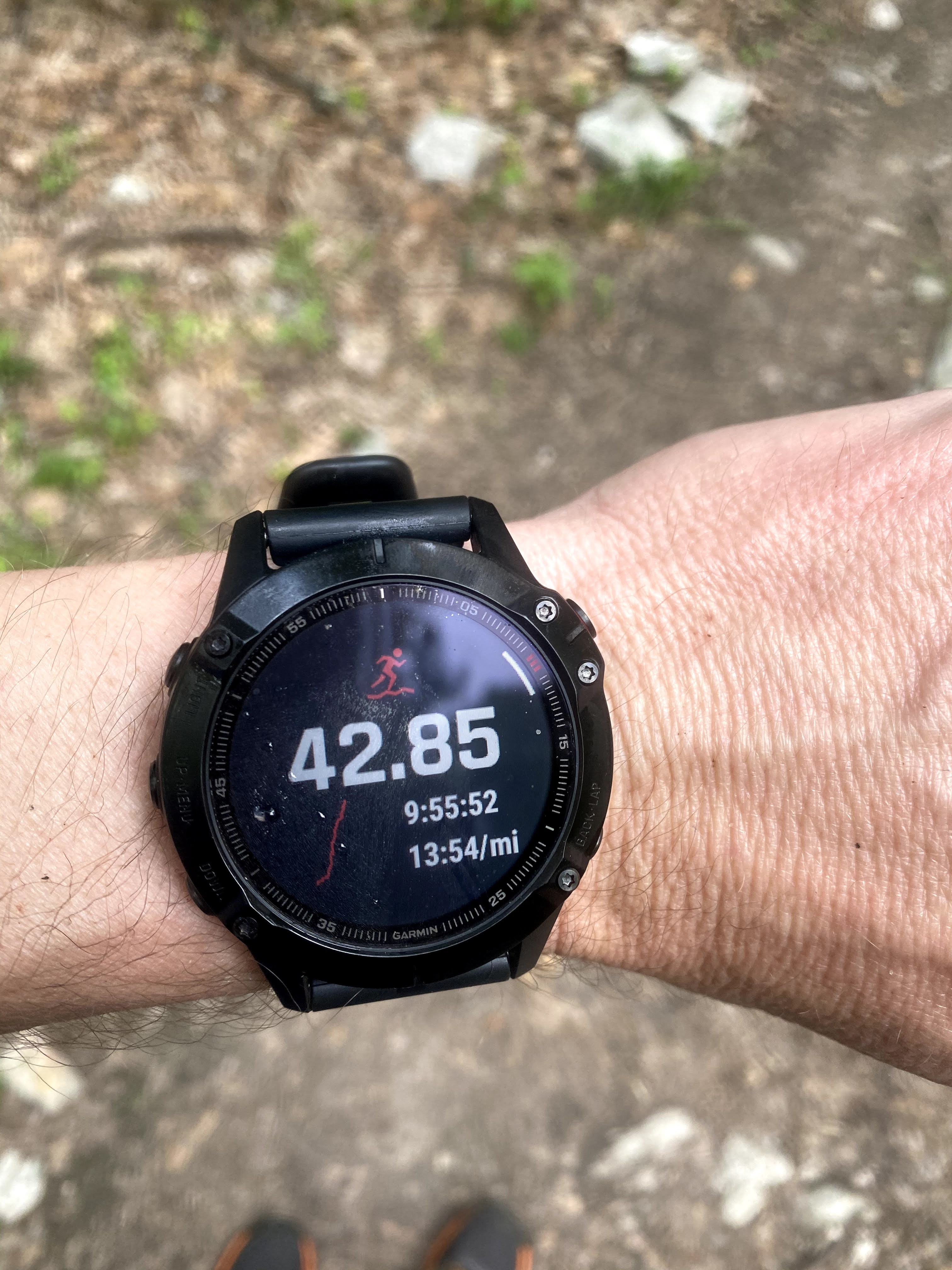
Total miles: 42.8
Total time: 9:55:52 (13:54 / mile)
Total moving time: 8:36:52 (12:04 / mile)
86,117 steps
7,434 feet in elevation Gain
7,470 feet in elevation Loss
746 floors climbed
1,843 feet in maximum elevation
323 feet in minimum elevation
5,375 estimated calories burned
3,158 estimated calories ingested
7,478 ml estimated sweat loss
7,500 ml estimated water ingested
Average heart rate: 138 bpm
Max heart rate: 171 bpm
Average temp: 76.0 degrees F
Max temp: 89.6 degrees F
Total training stress score of 381


During times like the ones 2020 has brought so far, I am so blessed to even have the opportunity to do such a challenge. Many people in this world are not afforded the time, resources, support, or health to do even a portion of this trail. I thank God for every blessing given to me and owe it all to HIM! The AT Challenge was a symbolic gesture that connected me from the North (PA) to the South (VA) and represented my own personal commitment to work on bridging the gap between our communities. I am committed to improving my outlook and vision of the bigotry and racism that exists and not to stand silent when I witness it.
A huge thank you to all my support in this endeavor including my patient and tolerant wife Tammy, my adorable and loving children Andrew and Natalie, and my amazingly supportive mother Ruth, and father John. They have always supported my adventures and I am forever thankful for the guidance, prayers, and love they have provided me in life. I would have no clue how to even try and attempt such a challenge without the wisdom of my coach Sierra. She always knows when to prod just enough to make me move!

No comments:
Post a Comment
Thank you for your comment. I will review it and be sure it is a positive contribution to the ideas or conversation. Bullying, foul, abusive, or inappropriate content will not be accepted. I will do my best to allow for a productive discussion in the comments to my thoughts. This blog is just that, my thoughts as I journey through the path God has me on. We are human, we make mistakes, and I strive to learn from all of them. Your comments are embraced as a part of that discipline. For that I am thankful for you to take the time to share your thoughts.